Development of metorological service in Bosnia and Herzegovina
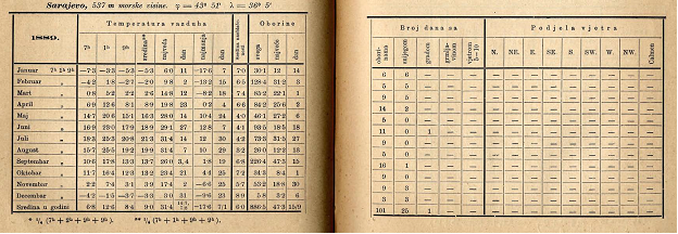
The beginning of meteorology in Bosnia and Herzegovina is related to the establishing of a network of meteorological stations in the 1880s, the times when BiH was a part of the Austro-Hungarian Monarchy. The first organised meteorological observations and measurements were conducted by the Austro-Hungarian army in 1879, when first meteorological stations were set up in Sarajevo, Mostar and Tuzla, all Class II stations. Subsequently, the National Government of Bosnia and Herzegovina established a dense network of meteorological stations, in line with standards of that time, and in 1900, a central institute was established in Sarajevo. In 1902, Sarajevo and Mostar became Class I stations, Banja Luka, Travnik, Bihać and Tuzla Class II, and there were 68 Class III stations. In 1892 began regular annual publishing of observation and measurement results from the network of meteorological stations.
In 1892, Fillip Ballif becomes the head of the meteorological service, and he was the one who gave the greatest contribution to the establishing of meteorological service in Bosnia and Herzegovina. Beside his endeavours to maintain continuity of observation services, he has significantly contributed to the practical use of the data. The result of his work is a map of average precipitation in Bosnia and Herzegovina.
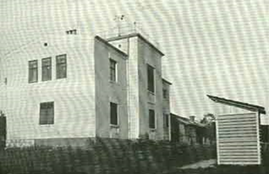
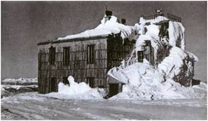
The Bjelašnica Observatory played an important role in the network of meteorological stations of that time. On 1 August 1894, it was commissioned as the station at the highest altitude in the Southeast Europe. The idea to set up an observatory at the summit of Bjelašnica came from the Director of the Centralanstalt za Meteorologie und Erdmagnetismus, Julius Hann, and the founder of the meteorological services in Bosnia and Herzegovina, Filip Ballif.
After Balif left in 1905, the development of the meteorological service was brought to a standstill. The service was taken over by the Construction Authority and organised in a fully staffed meteorology office which later on, in 1918, transformed into the Meteorological Institute.
At the beginning of the WWI, Bosnia and Herzegovina had a respectable network of 78 meteorological stations. The data collected over this period were considered to be of good quality, and have been used for different purposes.
Between the two world wars, hydrometeorological service in Bosnia and Herzegovina was strongly affected by geopolitical circumstances, which inevitably affected the quality of data and the total number of meteorological stations (it ranged from 75 stations in 1919 to 8 stations in 1945).
After the WWII, the network of meteorological stations, which was a part of the meteorological network of former Yugoslavia, went down to 78 stations, while in 1955, it had grown up to 85 stations.
When Bosnia and Herzegovina gained independence in 1992, the Republic Hydrometeorological Institute in Sarajevo became the Meteorological Institute of Bosnia and Herzegovina. During the aggression against Bosnia and Herzegovina that began in 1992, majority of stations experienced interruption in continuity of measurements, with an exception of several stations that continued their operation even during the war. Since 1995, meteorological activities in Bosnia and Herzegovina were under responsibility of entity hydrometeorological institutes of Sarajevo and Banja Luka. In 1997, the Government of Bosnia and Herzegovina enacted an act to establish the Federal Meteorological Institute, and in 2007, it was renamed to the Federal Hydrometeorological Institute.
On 30 July 1994, Bosnia and Herzegovina, as a sovereign state, became a member of the World Meteorological Organisation (WMO) that coordinates collecting and exchange of meteorological data using the basic World Weather Watch (WWW) programme. This programme consists of three components: Global Observing System (GOS), Global Telecommunication System (GTS), and Global Data Processing System (GDPS).
Meteorological data from the BiH network of stations are integral to the European and global watch systems and are regularly made available for international exchange.
Working programmes for meteorological measurements were defined in 1950 at an international level, by the World Meteorological Organisation. According to their recommendations and rules, networks of meteorological stations were established in FPR/SFR of Yugoslavia, a member state, signatory of the WMO Convention. Depending on the working programme for which different measurements are conducted (climatology, weather forecast, agrometeorology), stations are categorised as: synoptic, climatological, agrometeorological and precipitation stations.
According to the organisation of work, meteorological stations are categorised as:
- main meteorological stations,
- regular (climate) meteorological stations,
- precipitation stations,
- automatic meteorological stations.
The main meteorological station is a station of the main FHMZ network where meteorological observers conduct 24-hour observations and measurements, according to a predefined working programme, for the purpose of: monitoring and forecasting the weather and the climate, studying of atmosphere, agrometeorology, technical meteorology, hydrology, environmental protection, and other economic activities and scientific disciplines.
At the main meteorological station, a comprehensive programme of observations and measurements is implemented, including recording of numerous meteorological elements and phenomena, as well as exchange of data according to the synoptic schedule. Data delivered as SYNOP reports are sent to international exchange.
Regular (climate) meteorological stations are organisational units where observations and measurements of meteorological elements and phenomena are taken for climatological and agrometeorological purposes, three times a day, according to the climatological schedule - at 7, 14, 21 hours (local time). Although performed by non-professional observers, the quality of their work shows high level of awareness of how important these measurements are. At climate stations, according to the working programme, measurements and observations of the most important climate elements are taken: temperature and relative air humidity, wind, cloudiness, precipitation volume, visibility, and atmospheric phenomena.
Precipitation stations are organisational units where precipitation measurements are taken at 7 AM, and meteorological phenomena are observed 24 hours a day. During the cold season, snow depth is measured, as well as snowfall. Measurements are taken by non-professional observers, and the data are mostly used in water management, civil engineering, electric power industry, etc.
Automatic meteorological stations are measurement systems that perform automatic continuous recording of meteorological data in real time, and transfer of data into the common information system. In the early days, these systems were used to take measurements at remote and inaccessible locations. The need to access the data in real time called for introduction of automated measurements over the recent years.
The network of automatic meteorological stations includes six automatic meteorological stations and 13 automatic precipitation stations; 24 hours a day, they measure one or more meteorological elements, and are integral to the FHMZ information system.
Such system of automatic weather stations is fully integrable in all sorts of monitoring, that is, operational monitoring and warning systems for potential extreme conditions.
Today, in Bosnia and Herzegovina, there is a network of stations under the Federal Hydrometeorological Institute. It is consisted of 15 meteorological stations: 12 main meteorological stations with systematised observation staff, three climate stations, six automatic weather stations, and 13 automatic precipitation stations. In addition to the above listed, the Federal Hydrometeorological Institute runs a network of hydrological and seismological stations, as well as a network of air quality monitoring stations.
Meteorological data, observed and measured at meteorological stations, form the basis of meteorological operations, weather and climate studies, and other applied scientific research related to the state of the atmosphere, especially agriculture, forestry, water management, electric power industry, civil engineering, maritime, land and air transport, tourism, etc.
The process of collecting, processing, controlling, and archiving meteorological data has evolved over the years. In the second half of the 1960s, station data were mainly recorded in observation logs, which were then submitted for further processing. In addition to the log form, the data were also provided in the form of a continuous record tapes for certain metrological elements (temperature, pressure, relative humidity, wind, insolation, etc.), as well as in form of various reports. After collecting, controlling and processing the data, multiannual sets of climatological data were produced, forming the basis for study and research of climate and weather.
From 1968 to 1980, as part of its regular activities, the then Republic Hydrometeorological Institute of Bosnia and Herzegovina sent data from stations to the Federal Hydrometeorological Institute in Belgrade, where data were computer-processed and published as different types of almanacs. They were distributed back to the hydrometeorological services of the former Yugoslavia.
The beginnings of computer processing in Bosnia and Herzegovina took place back in the 1980s, when data were stored on punched paper cards, and later on, magnetic tapes. A lot of it was lost in the process of salvaging the data from these media.
The process of digitisation of meteorological data continued after the war, in 1995, when the entire stock of monthly data sets since 1961 were scanned and stored in electronic form, which improved archiving and simplicity of use for various purposes. Since 2002, a system for automatic collection, control and storing of data in the database of the Federal Hydrometeorological Institute has been in place. Over the recent years, certain developments have taken place in accordance with the WMO recommendations such as: modernisation of meteorological measuring devices and equipment, introduction of new techniques for spatial display of meteorological elements (GIS-techniques), etc.
In the organisation of work of the hydrometeorological service, control of meteorological data is an integral part of the process of data collection and processing. Errors may occur due to various reasons - some occur during observation of measurements, and some during data processing. The control detects obvious errors first, and those can be accidental or systematic. Errors can be related to a single element or a station, or to several elements at several stations, etc.
The process of data control includes verification of physical and climatological limits, minimum and maximum extreme values (e.g. relative humidity cannot be above 100%), internal data consistency based on mutual compliance of two meteorological elements (for example, both elements are suspicious if the cloudiness is = 0 and insolation is also = 0) and spatial control which implies a comparison with the data recorded at the nearest station showing similar meteorological characteristics.
Moreover, when such a phenomenon is detected during routine observation, the results may seem suspicious in comparison with the nearby observations carried out at the same time.
The climate atlas was produced using the data from main, meteorological, climate and precipitation stations on the territory of the Federation of Bosnia and Herzegovina collected during the period 1961-1990. The total of 117 meteorological stations was taken into consideration, out of which 16 main stations met the following mandatory mapping criteria:
- Uninterrupted data sets for the period 1961-1990;
- The station has not changed its location;
- Changes in the immediate surroundings have not affected the quality of measurements and observations;
- Homogeneous data sets for the period 1961-1990.
The Class II network consists of 42 meteorological stations, and the criteria they had to meet were mostly identical to the previous, except for the criteria of completeness of the data sets, where a 5% tolerance is allowed.
The Class III network consists of 59 meteorological stations and 579 precipitation stations, and these had to meet the following criteria:
- Completeness of data sets cannot be below 75% of the monthly data;
- The station has not moved for more than 2 km;
- Changes in the immediate surroundings have not affected the quality of measurements and observations;
- Homogeneous data sets for basic parameters (temperature and precipitation).
The missing data were replaced using approximation. When choosing a reference station according to which the data would be approximated, the distance, altitude, relief, climatic region, continentality, the influence of the sea, lake or river, were taken into account.
For the approximation of the missing measurements data, mathematical methods of proportions, correlation analysis, probability and interpolation were used.